Once the idea to expand the County Convention Center and add a headquarters hotel began to be discussed, it quickly became clear that the project offered a once-in-a-lifetime opportunity to create an iconic waterside development on the site of the existing facility, to take full advantage of the site’s potential as a “gateway” to Broward County, and connect it to other assets in the vicinity.
Site Identification
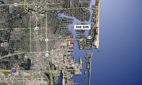
The project site was identified as a 40-acre area, bounded by the Intracoastal Waterway to the east, various port and cruise ship functions to the east and south, Eisenhower Boulevard to the west, and 17th Street and the 17th Street bridge to the north.
There are 2.1 acres of water, leaving a net area of 37.9 acres. In addition to the current Broward County Convention Center, which is 600,000 square feet, the tract area includes Broward County's Port Everglades’ Terminal 1 building, which is planned to be demolished, and the Northport parking garage, which contains 2,400 parking spaces shared by Port Everglades, the Convention Center and the former Portside Leasehold area. Surface lots to the west along Eisenhower Boulevard and to the north abutting 17th Street bring total parking to 3,175 spaces.
Site Analysis
To advance the vision, project planners conducted critical analyses in a number of key areas. The team:
- Reviewed previous studies with a similar scope
- Conducted formal public outreach to engage stakeholders and the public
- Researched the various jurisdictions and interests governing future development of the site
- Became familiar with all the material aspects of the site including buildings, infrastructure and landscape; how they function; and identified areas with potential for expansion and improvement
- Studied the surrounding development by use, density and special identifying features, their relationship to the convention center site, and identified how they could be used to advantage in the project
- Reviewed the character of the different bodies of water impacting the site
- Analyzed the circulation of a wide variety of transportation modes, including public, private, pedestrian, vehicular, bus and service vehicles, to ensure that the complex would function efficiently after an expansion
- Analyzed parking
- Recommended appropriate sustainability features, including orientation, sun angles, potential for storm water retention, efficiencies in energy systems and building technology
