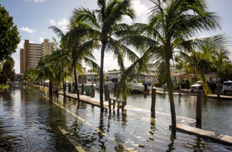
Sea level rise is increasing the frequency and severity of tidal flooding across Broward communities.
Recently, increased flooding has prompted both public and private investment in seawall improvements. Yet individual investments have not fully delivered expected flood protection benefits when adjacent and nearby seawalls continue to allow the trespass of water. Effective community flood protection requires a holistic approach.
Consistent seawall heights are necessary to protect the community from escalating impacts. Broward County has created regional guidance so that coastal flood barriers will continue to provide protection, even under future sea level rise conditions.
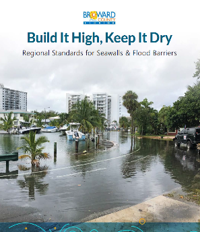
Download the Brochure
“Build it High, Keep it Dry: Regional Standards for Seawalls & Flood Barriers”
 SeawallDevelopers-Brochure-ADA-Web.pdf
What is the new Regional Standard?
Adopted by the Broward County Board of Commissioners on January 7th, 2020, as a part of the land use plan, Policy 2.21.7 applies to all tidally influenced properties within Broward County.
POLICY 2.21.7 In order to ensure coordination, consistency and maximum effectiveness of improvements necessary to mitigate high tide flooding associated with realized and additional sea level rise through the year 2070, tidally-influenced municipalities shall adopt within 24-months of the effective date of this Policy (February 13, 2020), regionally consistent top elevations for seawalls, banks and berms, and other appurtenant infrastructure (e.g., boat ramps) consistent with the findings and recommendations of the United States Army Corps of Engineers/Broward County Flood Risk Management Study for Tidally Influenced Coastal Areas. These standards shall be consistent with Chapter 39, Article XXV – Resiliency Standards for Flood Protection - of the Broward County Code of Ordinances, which shall serve as the model ordinance, and shall not be applicable to oceanfront beaches or shorelines seaward of the Coastal Construction Control Line.
Local governments are required to adopt a local ordinance implementing the regional standard by February 13, 2022.
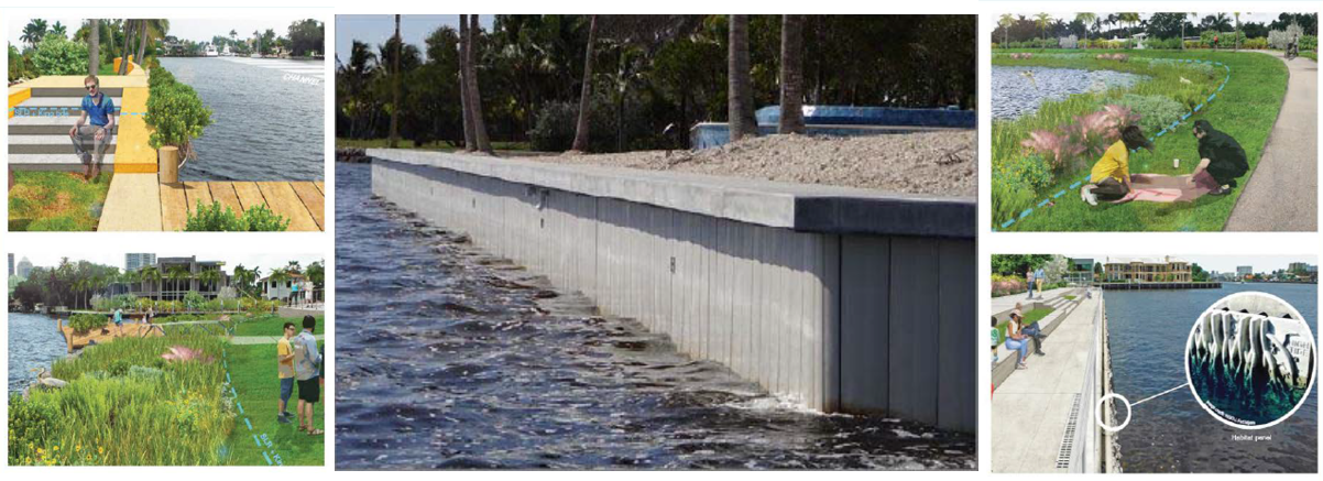
Seawall Replacement Alternatives to Provide Flood Protection and Enhance Habitat & Property Value
The brochure is now available
Resilient Shorelines Brochure
ARTICLE XXV. – RESILIENCY STANDARDS FOR TIDAL FLOOD PROTECTION
Adopted by the Broward County Board of Commissioners on March 31st, 2020 into the Broward County Code of Ordinances (Code), Article XXV within Chapter 39 serves as a model code and planning foundation for municipal adoption of regionally consistent minimum standards and a basis for resilience investments across the community.
Sec. 39-404. Purpose and intent.
The purpose of this article is to establish a consistent minimum elevation for tidal flood barriers that will:
(a) Provide a standard for flood mitigation infrastructure that serves as a barrier to tidal flooding, not seepage, by accounting for water levels predicted under combined conditions of sea level rise, high tides, and high frequency storm surge through the year 2070; and
(b) Ensure new shoreline structures and major shoreline improvements are designed for use as tidal flood barriers through application of consistent standards that account for future predicted tidal flood conditions and coastal water levels associated with sea level rise in accordance with current regional sea level rise projections, as updated and adopted by the Broward County Board of County Commissioners.
Sec. 39-405. Applicability.
This article applies to all new tidal flood barriers, substantial repair or substantial rehabilitation to shorelines and shoreline structures, and the installation of any fixed infrastructure attached to tidal flood barriers (such as mooring structures). This article is not applicable to oceanfront beaches or shorelines seaward of the Coastal Construction Control Line.
Sec. 39-406. Definitions.
For the purposes of this article, the following terms, phrases, words, and their derivation shall have the meanings given herein, except when the context clearly indicates a different meaning. In the interpretation and application of this article, the definitions provided for herein shall control over definitions that may be included in other documents or manuals, including, but not limited to, the Florida Building Code. Words used in the present tense include the future tense, words in the plural number include the singular number, and words in the singular number include the plural number. The word "shall" is mandatory and the word "may" is permissive.
Bank means the level space separating a waterway from an inland area, often elevated and constructed of compacted soil.
Berm means an earthen mound designed with impermeability to resist the flow of tidal waters through it to an adjacent property or public right-of-way.
Green-grey infrastructure or
green-grey materials means a combination of engineered and natural features that provide environmental qualities and ecosystem value.
Mooring structure means a boat dock, slip, davit, hoist, lift, floating vessel platform, mooring pile, or similar structure attached to land or to a seawall, to which a vessel can be moored.
North American Vertical Datum (NAVD88) means the vertical control for datum of orthometric height established for vertical control surveying in the United States of America based upon the General Adjustment of the North American Datum of 1988.
Public nuisance means a condition injurious to the public health or safety of the community or neighborhood, or injurious to any considerable number of persons, or a condition that obstructs the free passage or use, in the customary manner, of any public right-of-way.
Rip-rap means a foundation of unconsolidated boulders, stone, rubble, concrete without protruding rebar, or similar materials placed on or near a shoreline to mitigate wave impacts and prevent erosion.
Seawall means a vertical or near vertical (often interlocking) structure placed between an upland area and a waterway or waterbody for erosion control.
Seawall cap means a concrete box structure (usually reinforced) that connects seawall panels, piles, and anchoring system (if present) together at the top.
Shoreline means a tidally influenced area where land meets water.
Substantial repair or
substantial rehabilitation means:
(a) Any modification to the shoreline or a shoreline structure along more than fifty percent (50%) of the length of the property's shoreline; or
(b) Any modification, alteration, or installation of an appurtenant structure (such as a mooring structure) that exceeds fifty percent (50%) of the cost of a tidal flood barrier along the property's shoreline.
Tidal flood barrier means any structure or shoreline feature including, but not limited to, banks, berms, green-grey infrastructure, seawalls, seawall caps, upland stem walls, or other infrastructure that impedes tidal waters from flowing onto adjacent property or public right-of-way, and located within or along a tidally influenced area. This definition is not meant to include rip-rap, derelict erosion control structures, or permeable earthen mounds that do not provide an impermeable water barrier to tidal flooding.
Tidally influenced area means the real property adjacent to, or affected by, a waterway with water level changes in response to the daily tide.
Sec. 39-407. Minimum elevations for coastal infrastructure within tidally influenced areas.
(a) All new or substantially repaired or substantially rehabilitated banks, berms, green-grey infrastructure, seawalls, seawall caps, upland stem walls, or other similar infrastructure shall be designed and constructed to perform as tidal flood barriers. Tidal flood barriers shall have a minimum elevation of five (5) feet NAVD88. Applications for new or substantially repaired or substantially rehabilitated tidal flood barriers submitted prior to January 1, 2035, may be permitted a minimum elevation of four (4) feet NAVD88, if designed and constructed to accommodate a minimum elevation of five (5) feet NAVD88 by January 1, 2050.
(b) All property owners must maintain a tidal flood barrier in good repair. A tidal flood barrier is presumed to be in disrepair if it allows tidal waters to flow unimpeded through or over the barrier and onto adjacent property or public right-of-way. Failure to maintain a tidal flood barrier in good repair shall be a citable offense. The owner of the tidal flood barrier shall demonstrate progress towards repairing the cited defect within sixty (60) days after receiving a citation and shall complete repairs within three hundred sixty-five (365) days after receipt of the citation. If the required repair or rehabilitation meets the substantial repair or substantial rehabilitation threshold, no later than three hundred sixty-five (365) days after receipt of the citation, the property owner shall design, obtain permits, cause to be constructed, and obtain final inspection approval of seawall improvements that meet the minimum elevation and design requirements.
(c) Tidal flood barriers below a minimum five (5) feet NAVD88 elevation shall be improved, designed, and constructed so as to prevent tidal waters from impacting adjacent property or public right-of-way. Causing, suffering, or allowing the trespass of tidal waters onto adjacent property or public right-of-way is hereby declared a public nuisance and a citable offense requiring abatement. The owner shall demonstrate progress toward addressing the cited concern within sixty (60) days after receipt of the citation and complete the construction of an approved remedy no later than three hundred sixty-five (365) days after receipt of the citation.
(d) Tidal flood barriers shall be designed and constructed to prevent tidal waters from flowing through the barrier, while still allowing for the release of upland hydrostatic pressure.
(e) To the extent practicable, tidal flood barriers shall be designed and constructed to adjoin immediately proximate tidal flood barriers to close gaps and prevent trespass of tidal water.
(f) All tidal flood barriers undergoing substantial repair or substantial rehabilitation shall be constructed along the property's entire shoreline.
(g) All tidal flood barriers shall be constructed with natural limerock rip-rap, or other approved habitat enhancement, at the waterward face of the structure.
(h) Property owners are encouraged to consider approaches and materials that enhance the biological value of traditional (flat surface) seawalls and flood barriers with the incorporation of living shoreline features, use of hybrid green-grey materials, and the use of biological forms, where practicable.
(i) This section shall not be construed to require the installation of a seawall where other flood protection measures serve as an equally effective tidal flood barrier.
(j) Tidal flood barriers capable of automatically being elevated in advance of high tides to prevent tidal flooding are permissible, provided that automation cannot require daily human intervention.
Sec. 39-408. Required disclosure in contracts for sale of real estate.
In any contract for the sale of real estate located in tidally influenced areas of Broward County executed after December 31, 2020, the seller shall include in the contract or a rider to the contract the following disclosure in not less than fourteen-point, capitalized, bold-faced type:
THIS REAL ESTATE IS LOCATED IN A TIDALLY INFLUENCED AREA. THE OWNER MAY BE REQUIRED BY COUNTY OR MUNICIPAL ORDINANCE TO MEET MINIMUM TIDAL FLOOD BARRIER ELEVATION STANDARDS DURING CONSTRUCTION OR SUBSTANTIAL REPAIR OR SUBSTANTIAL REHABILITATION OF SEAWALLS, BANKS, BERMS, AND SIMILAR INFRASTRUCTURE OR WHEN REQUIRED TO ABATE NUISANCE FLOODING.
Policy Support: Risk Assessments and Modeling
The regional standard was informed by technical work undertaken with support from the U.S. Army Corps of Engineers (USACE) as part of the joint Broward County/USACE Flood Risk Management Study for Tidally Influenced Costal Areas authorized under the Planning Assistance for States Program.
The study focused on two tidally influenced coastal areas (not direct oceanfront) located within the County, to address flooding problems experienced in these areas:
- Las Olas Isles area in the City of Fort Lauderdale
- Hollywood Lakes area in the City of Hollywood
These areas and other low elevation coastal areas experience nuisance "sunny day" flooding during the highest tides of the year (i.e. King Tides). This flooding has become more frequent and severe over time due to rising sea levels and more severe storms.
The USACE collected water, ground, and seawall elevation data to model existing local conditions. This data was combined with rainfall, storm surge, and groundwater models to estimate peak water elevations. The USACE modeled various combinations of high tide levels and high frequency 5, 10, and 20-year storm surge events, in addition to alternative future conditions with +1 and +2 feet of sea level rise.
The USACE modeled the impacts of potential improvements to seawalls, which includes filling in existing seawall gaps, raising existing seawalls, and installing additional seawalls. The USACE may model other potential improvements, including raising streets, installing backflow preventer valves on stormwater drains, installing additional pumping capacity, and other structural and non-structural actions. The report can be downloaded for your review. Additionally, the presentation from the September 10, 2018 stakeholder workshop are available to download.
Economic Analysis
Broward County consulted with Risk Management Solutions, Inc. (RMS) to undertake an economic impact assessment of potential economic losses caused by flood events. In 2018 RMS developed an exposure database of assets and operations potentially impacted by flooding and an assessment of hurricane storm surge hazard frequency and severity in the two study areas. The report can be downloaded for your review.
Ensuring Community Resilience, Together
Stakeholder engagement was a critical component of the planning process. Participation by the marine industry, real estate community, engineers and planners from both the private and public sector, and other stakeholders in extensive public meetings and surveys was integral to the adoption of a regional standard that could be utilized by and serve to benefit the entire community.
Planning now for future water levels benefits property owners in multiple ways. First, it is prudent to budget for the necessary adaptation before impacts to property values or infrastructure occur. Also, coastal flood protection measures that do not consider sea-level rise will likely require premature reinvestment to replace failed infrastructure at a significant expense to the property owner and the community at large. Property owners who ensure their coastal flood protection project is designed to meet the resiliency standard will be better positioned to protect their property and investment. Floodproofing may also reduce the level of required investment in surface water management infrastructure (pumps) for areas that will be below sea level in the future.
Recent presentations and discussion regarding the proposed policy can be viewed online.
Download the Deerfield Beach Public Presentation. To request a virtual presentation or outreach materials, contact resilience@broward.org.
