In an effort to reduce the effects of flooding, Congress created the National Flood Insurance Program (NFIP) in 1968. The Federal Emergency Management Agency has updated the Flood Insurance Rate Maps (FIRMs) for Broward County. One of the main goals of this effort is to more accurately define the boundaries of flood hazard areas, which are determined by comparing flood elevations with digital elevation data. To ensure that all the elevations used are based on a common reference system, a FIRM must reference a single vertical datum.
What is a Vertical Datum? A vertical datum is a set of constants that defines a system for comparing elevations. If someone were to measure to measure the height of the ground you are standing on, they would need a point of reference, or a zero (0.0) point, to measure from. But where is that zero point? A vertical datum establishes a consistent zero point so elevations can be compared with one another even if the elevation measurements are taken by different people at different times or in different parts of the state.
Why did the Vertical Datum Change? For many years, the zero point used throughout the United States was based on “mean sea level” at 26 separate tidal stations in the US and Canada. This datum was referred to as the National Geodetic Vertical Datum of 1929 (NGVD 29). The main assumption used to create NGVD 29 - water level is equal all along the coast and thus represents the same zero- later proved to be erroneous and was shown to create errors in the elevation data obtained using this datum. This means that using the outdated vertical datum, two different points measured at 0.0' NGVD 29 can have different actual elevations. In the NFIP, the vertical datum is crucial because all elevations need to be as accurate as possible and referenced to the same zero point. Otherwise, surveys may show different elevations for the same point, which could result in flooded structures and losses. The old FIRMs (i.e., FIRMS in effect prior to the adoption of the current FIRMS on August 18, 2014) referenced the outdated National Geodetic Vertical Datum of 1929 (NGVD 29). We can now more accurately measure vertical elevation differences using the new official U.S. vertical datum, the North American Vertical Datum of 1988 (NAVD 88). With the new FIRM updates, this more accurate datum will be used (NAVD 88), resulting in a difference of minus 1.51 feet between elevations shown on the new (2014) FIRM as opposed to the old (1997 and prior) FIRMs.
When did the Vertical Datum Change? Elevations in NAVD 88 for floodplain management and flood insurance purposes (e.g., elevation certificates) in Broward County should be used as of August 18, 2014, the effective date of the current flood maps. In preparation for that change, Environmental Permitting Division began requiring the new datum for surveys and plans submitted with applications beginning on January 30, 2011.
Who is Impacted by the Vertical Datum Change? The change in vertical datum affects all those using FIRMs or submitting applications for building permits or environmental licenses in Broward County, including engineers, surveyors, developers, homeowners, lenders, insurance agents, realtors and floodplain administrators, especially when comparing elevation data on the new FIRMs, produced using NAVD 88, with data on older FIRMs produced using NGVD 29.
Points to Know:
- Changing from a measuring method developed in 1929 to one developed in 1988 means greater accuracy in determining land and water elevations.
- Instead of relying on “mean sea level” to determine the elevation of a point, Broward County utilizes the sophisticated elevation reference system for the North American continent. Eventually, all cities and counties in North America will use this same network of vertical reference points to support many diversified uses.
- Broward County databases will retain information in both the NGVD 29 and the NAVD 88 vertical datums in order to maintain historical data.
- Anyone who uses elevation information in Broward County needs to know about, understand and apply the new measuring standards.
- A conversion application is available so that users can readily convert elevation data from NAVD 88 to NGVD 29, and vice versa. You are able to compare “apples to apples” using the free conversion software VERTCON. In addition, FEMA has computed an average conversion factor for Broward County of minus 1.51 (-1.51) that may be used to provide a more rough conversion between the two datums.
- It is always more precise to convert elevations from the more accurate NAVD 88 vertical datum to the NGVD 29 vertical datum. Because of inherent flaws in the NGVD 29 datum, values converted from NGVD 29 to NAVD 88 will not exceed the accuracy of the source data. If exacting elevations are required, a new survey utilizing NAVD 88 values should be considered.
Conversion Factor Example
A building finished floor elevation is shown on an existing elevation certificate as 10.0’ NGVD. The equivalent NAVD 88 elevation can be obtained using the FEMA-approved average conversion factor in the following formula:
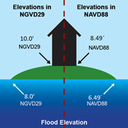 NAVD 88 = NGVD 29 + conversion factor
NAVD 88 = 10.0’ NGVD + (-1.51)
NAVD 88 = 8.49
View Enlarged Graphic
Is Further Information Available? If you have any questions regarding vertical datum changes or the NFIP in general, please contact the FEMA Map Assistance Center toll free at 1-877-FEMA MAP (1-877-336-2627). Additional information about the NFIP is available here. Current elevation, description, or location information for bench marks in Broward County is available here.
Learn more about vertical datums and vertical datum conversion:
